Co-authored with Harvey Logan (@harv_logan / www.theairplanesblog.wordpress.com)
Welcome back, and we trust you have refuelled and are ready for another journey through the geographies of the air! Part one of this two-part series, where we explored air’s importance in creating a sense of place, air as a medium, and some cultural geographies of air, can be found here.
In the post below, we explore the militarisation of airspace and aerial intensification, we discuss how much attention air might deserve in the future, and we take a brief look at whether there is room in the school curriculum for a deeper consideration of the geographies of air.
Militarised airspace
Militarised air power, much like air pollution, often disrespects borders. The shooting down of commercial airliners is one obvious example. PS752 and IR655 in Iran, MH17 in Ukraine, KAL007 in Russia. This list is not exhaustive. It is important to remember that it is not only rebel groups or insurgent governments who shoot down airliners – IR655 was downed by the US Navy.
Battles in the air are rarely fought over territory. They are strategic endeavours or shows of power and involve a significant amount of what could be construed as ‘willy waving’. Long-range missions by Russian aircraft venture close to the airspace boundaries of the USA or its NATO allies, and elicit a response from fast jets like those in the RAF’s QRA squadron. American ‘spy planes’ regularly undertake 30+ hour sorties from US the East Coast to the Baltic and back again, supported by aerial refuelling tankers, essentially just to show they can. Airspace in the Alaskan region has seen a lot of this type of military activity recently, with clear geopolitical links to both nations’ ambitions in the Arctic.
Concerns have been raised for decades about militarised urbanism (see, for example, Mike Davis’s City of Quartz), but these have risen in more popular consciousness recently with the targeted use of military resources in urban environments becoming more commonplace. Low-flying helicopters, operated in a manner incompatible with accepted safe procedures, were used this year to disperse BLM protesters in New York City and Washington DC, as shown in this video: https://www.nbcnews.com/video/watch-helicopters-hover-low-over-protesters-in-washington-84223557542.
Drones
The military applications of unmanned drones (UAV’s) can be criticised for encouraging a lack of restraint in combat as there are no ‘lives on the line’. People living in conflict zones have reported feeling a state of fear when skies are blue, as they know drones will be flying.
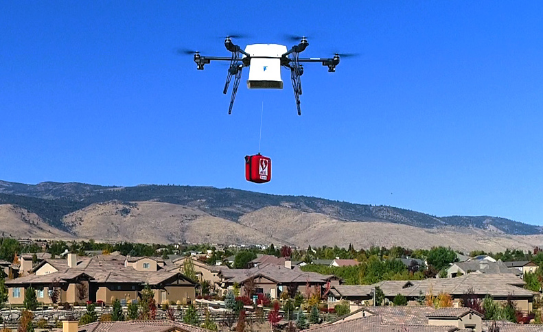
Equally though, drone technology has contributed to beneficial and humanitarian developments. The inclusion of UAV’s in medical supply chains can be life changing in rural areas. Drones can revolutionise the delivery of blood, medicines and vaccines to remote health facilities where land-based transport is hard to come by (see Fig.1 and https://www.doveair.org). For some countries, especially where roads are scarce and of poor quality, UAV’s may be the only way to deliver a refrigerated COVID-19 vaccine to rural and isolated areas before it thaws.
UAV’s can also be used for GIS or mapping, assisting in the creation of high-quality maps and 3D models which can be used to assist with humanitarian disaster response or climate science, amongst other things (http://www.sensefly.com/industries/case-studies).
Aerial intensification
The increasing usage of drones for deliveries may herald a new ‘aerial intensification’, bringing into play considerations of aerial congestion, noise pollution, collisions, and risks to other animate and inanimate objects. These issues will be even more important to contemplate when humans are brought into the mix: ‘urban air mobility’ (UAM) and the concept of the ‘flying car’ have prompted social concerns relating to airspace. With UAM, this includes the ability to use aerial transport to opt-out of shared public space – see, for example: https://www.americanprogress.org/issues/economy/reports/2020/05/28/481148/flying-cars-will-undermine-democracy-environment/
The development of UAM will move urban airspace into the regulatory lens of urban planning. Decisions around land use will incorporate airspace as an important aspect of the city and its transport network rather than simply as empty space.
And it is not just flying vehicles using the air for transport. There is a growing number of urban cable cars around the world. See here: https://www.londonreconnections.com/2020/the-incredible-lightness-of-being-cable-cars-a-legitimate-urban-transport-mode-but-not-in-the-uk/
A declining concern?
Aside from pollution and climate change, understanding the ways that humans interact with the air may in the near future be a declining concern, as environmental regulations, moral concerns (such as voluntary scaling back and ‘flight shaming’), and the growth of high speed rail lines, especially in emerging economies, may stymie the growth of flights.
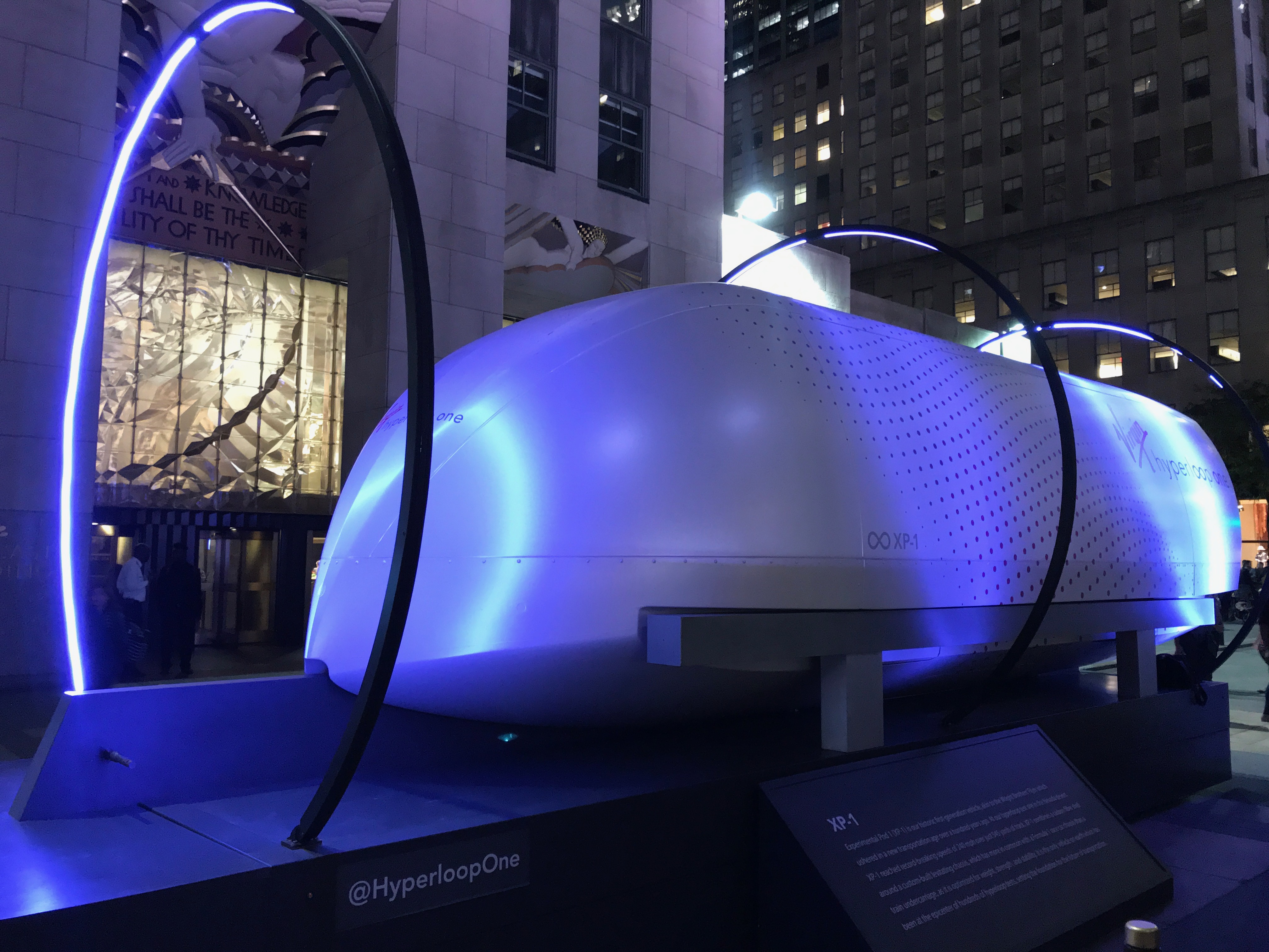
Some commentators suggest that hyperloops (see Fig. 2) (or perhaps maglevs and vactrains, for those of us who approve of the technology but not of Musk’s assessment that “Individualised mass transit is the future”) may reduce intra- and even inter-continental travel by air. The massive drop in air traffic thanks to covid-19 related restrictions and fears may accelerate this decline. This downturn may be a temporary one, but will we see a shift away from more ‘superfluous’ flights such as for meetings and job interviews? Conference calling capabilities have improved and have become commonplace. Also, an increase in virtual reality technology could mean that such remote meetings might begin to feel more visceral.
On the other hand, airspace may retain its importance, as a greater focus on airspace management (including next-generation air traffic control and restricting contrails) is one of the best tools to reduce aviation emissions in the medium-term. Along with drones and urban air mobility, this will require us to start changing how we use airspace. In these respects, airspace is not a declining concern.
Moreover, continuing economic development in emerging and developing countries will almost certainly lead to an increase in flights; see, for example, the growth of the China-Africa airlink, which will override the ‘first world’ trends of flying less. And although it could be a long time away, the widespread adoption of more environmentally friendly forms of aviation may also lead to a busier aerospace.
Air and outer space
Although ‘air’ is not synonymous with ‘outer space’, there is a continuum between the two, and geographers should note that control of outer space has risen up the geopolitical and business agenda – here, one thinks of Space X, the renaissance of missions to Mars, the United States Space Force and an emboldened China, whose most recent mission, Chang’e 5, has reinvigorated debate about lunar missions. There is an overlap here with next-generation airspace management, as satellite-based aircraft tracking has enabled this.
Air in the curriculum
The Key Stage 3 national curriculum programme of study for geography explicitly focuses on “the location of globally significant places – both terrestrial and marine” (Department for Education, 2013: 1) but there is no mention of the air. And whilst contested maritime boundaries feature in all A Level specifications, only limited attention is given to geographies of the air that are not specifically physical. One exception is Edexcel’s mention of air power in its Superpower unit, and even then, it is only made explicit in the context of the costs of maintaining such power:
“7.9 Existing superpowers face ongoing economic restructuring, which challenges their power … b. The economic costs of maintaining global military power (naval, nuclear, air power, intelligence services) and space exploration are questioned in some existing superpowers.” (Edexcel, 2016: 53)
Stretching the definition of air (a mixture of gases that surround a planet) to include the gaps between planets and the definition of geography (study of the earth) to embrace considerations of interactions between humans and outer space has led to an increased range of areas for geographical study, for example the governance of space as a contested ‘commons’ does feature in some resources aimed at A Level students.
Of course, the geography curriculum, especially at secondary school level, is already crowded… so can it afford to take it on?
Conclusion
We feel that geographers should spend some time contemplating how the issues that we discuss above are interdependent and how we might conceive of a more robust and wide-ranging geography of the air that takes it beyond its home in physical geography and meteorology.
In an age of a globally prevalent virus which cannot be seen by the naked eye, it is time for an increased awareness that the invisible is crucial in geography. The air is a neglected aspect of our discipline which is ‘hiding in plain sight’.
David Alcock (@DavidAlcock1 and www.alcock.blog)
Harvey Logan (@harv_logan and www.theairplanesblog.wordpress.com)
December 2020
References
(Most references are hyperlinked)
Department for Education (2013) Geography programmes of study for England: key stage 3: National Curriculum – Geography key stages 3 and 4 (publishing.service.gov.uk)
Edexcel (2016) GCE A level Geography specification issue 5: https://qualifications.pearson.com/content/dam/pdf/A%20Level/Geography/2016/specification-and-sample-assessments/Pearson-Edexcel-GCE-A-level-Geography-specification-issue-5-FINAL.pdf

