
Figure 1: View of Montserrat from International Space Station, 2009
Source: http://earthobservatory.nasa.gov/IOTD/view.php?id=40803&src=eoa-iotd
All A-level examination specifications have tectonic hazards as an option. It can be difficult to keep up-to-date with recent case studies, especially those concerning continuing volcanic events and long-term responses. Montserrat is a popular case study, but its appearance in some of the most popular Key Stage 3 and GCSE textbooks might put students off revisiting the case study at A-level. However, the situation in Montserrat is complex and constantly changing, and this justifies revisiting the ‘little island with the large volcano’. In this article, we will consider the physical processes involved in recent volcanic activity, and we will assess the monitoring and prediction techniques employed on the island. In the second article, we will consider the long term impacts of the eruptions and the potential for the island to become self-sufficient.

Figure 2: Location of Montserrat – in the easterly part of the Caribbean
Source: https://www.cia.gov/cia/publications/factbook/reference_maps/pdf/central_america.pdf

Figure 3: Map of Montserrat
Source: http://www.paradise-islands.org
Phases of volcanic activity
Scientists at the Montserrat Volcano Observatory (MVO) have divided the volcanic activity into five phases interrupted by pauses:
Phase 1: Summer 1995 to the start of 1998
Phase 2: December 1999 to Summer 2003
Phase 3: Summer 2003 to Spring 2007
Phase 4: Summer 2008 to 3 January 2009
Phase 5: 4 October 2009; ongoing (at time of writing – i.e. October 2010)
The main events which Geography students will be familiar with occurred in Phase 1. Following over three hundred years of inactivity, there were a few precursors of activity early in 1995, in that steam was seen rising from the vent, and mud pools increased in temperature. The first eruption of the Soufrière Hills Volcano started on 18 July 1995, and this initial eruption led to the evacuation of the capital, Plymouth, and the creation of an exclusion zone in the southern part of the island. On 25 June 1997 at about 1pm, a much larger eruption occurred. The dome of the volcano collapsed, sending 5 million cubic metres of hot rocks and gases down the side of the volcano. These ‘pyroclastic flows’ killed 19 people who returned to their farms in the exclusion zone, and they also created an area of new land as some debris was deposited off the coast. Activity in Phase 1 had significant impacts on the society (notably the emigration of over half of the island’s population), economy and environment; these will be dealt with in detail in the next article. Activity in Phases 2-5 has been significant enough to warrant the continuation of the exclusion zone, although no further fatalities have occurred. We will now investigate the most recent phase, to give some idea of the events associated with a volcanic eruption.
Phase 5 of volcanic activity
Phase 5 has enjoyed more media exposure than all but the first phase, partly owing to the publication of an aerial photograph of the eruption taken by an aeroplane passenger in the national press and on several websites (see Figure 4).
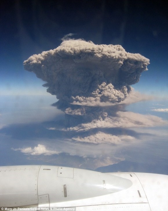
Figure 4: 2010 eruption, taken by an aeroplane passenger
Source: http://www.solentnews.co.uk/
Phase 5 began on 4 October 2009, and was preceded by two days of decreasing gas output and an hour of small volcano-tectonic (VT) earthquakes. Ash was vented for the first four days, the dome grew, and pyroclastic flows were recorded, some of which reached places which had never been reached before. This episode ended with five Vulcanian explosions (powerful eruptions of blocks of viscous lava, also known as ‘volcanic bombs’) throughout a five-week period in January-February. At 11.52am on 11 February, an estimated 40 million cubic metres (approximately 20%) of the north-eastern portion of the lava dome collapsed (see figure 5 below). This led to several pyroclastic flows and surges. One flow/surge combination headed down Farm Valley (see Figure 7), which had not previously been affected by such activity – this surge was so powerful that the MVO described it as being “a small lateral blast type pyroclastic surge”. Lateral blasts will be familiar to students through the 1980 Mount St Helen’s eruption. The deposits added 650m of new land was added to the island’s coastline at Spanish Point (see map – Figure 3). This coastal accretion, together with other additions since 1995 have led to the joke that Montserrat is ‘the only part of the British Empire which is still expanding’.

Figure 5: Partial lava dome collapse, 11 February 2010
Source: ‘Report to the Scientific Advisory Committee on Montserrat Volcanic Activity – Report on Activity’ at http://www.montserratvolcanoobservatory.info
These pyroclastic deposits (see Figure 6) consist of ash, together with blocks of ‘andesitic glass’ – a porous, light-grey rock which is ejected at great speed from the vent, trapping water vapour from the magma as it forms. Some of this material is less dense than water, and it therefore often floats. These deposits have crystals of pyroxene embedded in them – these originate from the mingling of basaltic (silica-poor) and rhyolitic (acidic and silica-rich) magma. Once pyroclastic deposits settle, secondary explosions can take place – these occur hours, days, or even weeks after the flow. In such explosions, groundwater or rainfall comes into contact with the well-insulated and very hot deposits merely tens of centimetres below the exposed upper layer. The temperature can reach several hundreds of degrees Centigrade even at these shallow depths. The 11 February event also generated ash clouds of up to 40,000ft (12,200m) in height; the west-southwesterly winds meant that the ash only fell on a small part of eastern Montserrat; it did, however, make landfall on islands such as Antigua, Guadeloupe, Dominica, Martinique and St Lucia.


Figures 6 and 7: Pyroclastic deposits
Source: Author
How is the Soufrière Hills volcano monitored?
One of the ultimate aims of monitoring volcanoes is to identify precursors of activity. Of course, vulcanologists enjoy the advantage over earthquake seismologists of having a reasonable idea about where an eruption might take place, even if it is difficult to say precisely when activity is likely to take place.
The current monitoring system is maintained by staff at the Montserrat Volcano Observatory (MVO). There are several monitoring stations situated throughout the island. They are powered by solar panels, which continuously provide data to the MVO by radio link. A continuing challenge to scientists has been the threat of pyroclastic flows, pyroclastic surges, and lahars, which have frequently put several stations out of action. Sometimes, scientists have been extremely lucky; this was the case on 11 February, when a monitoring station was only 2 metres away from the ‘singe zone’ of the pyroclastic surge (see Figure 8).
The seismic network comprises twelve broadband seismometers which can detect ground motion in the frequency range from 0.03Hz to 50Hz: this range encompasses a range of movement, from human footfall, through rockfalls, to movements of magma deep underground. The GPS network has nine GPS receivers detecting ground deformation with an accuracy of millimetres. The gas spectrometers sample the plume for suplhur dioxide.
In addition, there are four monitoring stations set up by a British-American research project (SeaCALIPSO), each one containing a tilt- and a strain-meter housed in a 200m-deep borehole.

Figure 8: Monitoring station
Source: Author
Key terms
– Pyroclastic flow: A surface-hugging eruption cloud of very hot gas and volcanic particles that moves rapidly across the ground surface
– Pyroclastic surge: a surface-hugging hot cloud, less dense than a pyroclastic flow, moving with turbulent flow close to the ground surface (also known as a nuee ardente – French for ‘hot cloud’)
– Lahar: A volcanic mudflow
– Lava Dome: A build-up of viscous lava near a volcano’s vent
– Ash venting: The release of small particles of volcanic rock and glass
– Vulcanian explosion: A type of eruption consisting of the explosive ejection of incandescent fragments of new viscous lava, usually in the form of blocks
– Volcano-tectonic (VT) earthquakes: seismic episodes originating from volcanic activity
– Singe zone: The area adjacent to pyroclastic flow deposits, where vegetation has been partly or wholly burned
How is the monitoring equipment used?
The seismometers detect earthquakes, some of which, referred to as ‘low frequency events’ tend to appear in ‘swarms’ prior to an eruption. Some of these are cyclic, as magma forces its way through subterranean conduits (passageways), and indicate that a dome collapse is likely to occur. The GPS units are used to measure the ‘inflation’ of the island when magma builds up in a magma reservoir under the dome, and its ‘deflation’ following the extrusion of material (see figure 9). Gas spectrometers are used to detect patterns of releases of sulphur dioxide, which is a measure of the overall permeability of the volcanic ‘plumbing system’. The data from these networks can be combined into a single graph (see figure 10): red vertical bands show phases of extrusive activity (as mentioned above), whilst the green bands are when magma extrusion has paused. The tilt- and strain-meters complement these data in that they enable vulcanologists to detect ground deformation.
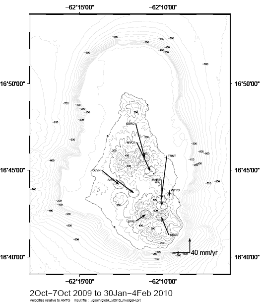
Figure 9: Map of GPS measurements showing dome deflation
Source: ‘Report to the Scientific Advisory Committee on Montserrat Volcanic Activity – Report on Activity’ at http://www.montserratvolcanoobservatory.info
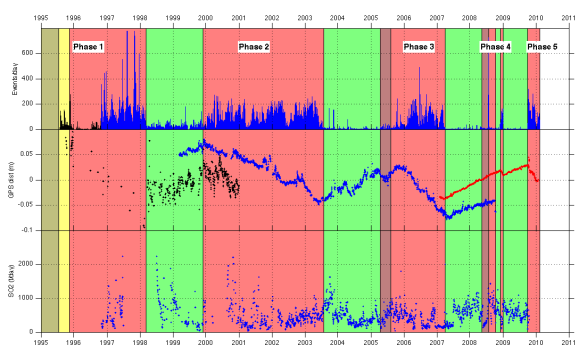
Figure 10: Graph showing combination of monitoring readings
Source: ‘Report to the Scientific Advisory Committee on Montserrat Volcanic Activity – Report on Activity’ at http://www.montserratvolcanoobservatory.info
Note that whenever magma extrusion has stopped, the GPS signal indicates an inflation of the magma reservoir, while magma extrusion is accompanied by a deflation of the reservoir, and therefore a slight ‘sinking’ of the centre of the island.
Other monitoring techniques
Two additional stations contain arrays of infrasound sensors to detect air pressure variations caused by slow degassing or gas eruptions. At the Montserrat Volcano Observatory itself, there is an observation platform and webcams, providing the benefits of a visual overview of activity, but with the drawback of being almost useless during times of heavy cloud cover and at night. There is also a thermal camera, which overcomes these problems of poor visibility.
How effectively can volcanic activity on Montserrat be predicted?
To what extent do vulcanologists believe that they can predict when an eruption on Montserrat is likely to occur? The Director of the MVO, Dr Paul Cole, uses a metaphor to explain why initial eruptions are usually relatively easy to predict:
“It’s much like an explorer creating a new path through the jungle. When he first cuts his way through, it takes a lot of effort, and he makes a lot of noise as he slowly works his way through the undergrowth. But with each repeated use of the path, the journey becomes easier, and there is less disturbance. With volcanoes, if the vent has been used after a long period of inactivity, the magma has to break through and widen faults, creating seismic signals, but with each subsequent eruption, the magma encounters fewer obstacles, and therefore leaves behind a weaker seismic trace.”
Dr Cole also takes care to mention that the activity of some other volcanoes, particularly those with more basaltic (less silica-rich) magma, is more ‘predictable’ than that of the Soufrière Hills volcano.
In Montserrat, volcanic activity has occurred in phases, and there are a variety of characteristic signals which correlate with such phases. However, it remains exceptionally difficult to predict when such phases are due to start or end, and it is equally hard to know when episodes of violent and extrusive vulcanicity will occur within these phases. Monitoring the Soufriere Hills volcano has helped to minimise its impact on the island’s residents, but its eruptions have had serious effects on the society, economy and environment of Montserrat. It is to these impacts that we will turn to in part 2 of this article.
Key points
- The Soufriere Hills volcano has been active in distinct phases
- Physical processes involved in eruptive phases are complex
- Despite sophisticated monitoring techniques, predicting volcanic eruptions remains extremely difficult
Points for discussion
- To what extent does media exposure influence our knowledge of hazards?
- What monitoring techniques do vulcanologists share with seismologists?
Further reading
‘Report to the Scientific Advisory Committee on Montserrat Volcanic Activity – Report on Activity’ at http://www.montserratvolcanoobservatory.info
Loughlin, S., Baptie, B. and McCourt, W. (2009) Monitoring Montserrat’s volcano – past, present and future
http://planetearth.nerc.ac.uk/features/story.aspx?id=396 dated 10 July 2009
Acknowledgements
This article was written following a field-trip to Montserrat with Dr Caroline Neuberg, Physics teacher at Fulneck School, Leeds, and three sixth form students at the school. The trip was made possible thanks to grants from the Seismic Schools Initiative based at the School of Earth & Environment, University of Leeds, UK (a seismometer was installed at the Secondary School) and the Royal Society. I am indebted to Professor Jurgen Neuberg from the University of Leeds for his help on the field trip and his comments on the text. Finally, I would like to thank all the interviewees mentioned above.

One reply on “The little island with a large volcano – Part 1: how is volcanic activity on Montserrat monitored?”
Reblogged this on Living on the Island of Montserrat.
LikeLike