Below are some of the ways that you could take learning outdoors in the humanities and beyond. They are based on personal experience and come from a session I presented at the Practical Pedagogies conference in Cologne (http://practicalpedagogies.net/) on 1st November 2018. Many thanks to the people and organisations who were the original source of many of these ideas – I have included weblinks and credits where I could. Please feel free to spread the word and to contact me for any more information/clarification.
Mental maps
As with any activity, it’s good to start with what students already know, so why not give them a blank piece of paper, and ask them to draw a ‘mental map’ of the place they are about to visit – or give them a map with outlines (for street maps of anywhere in the world: www.oomap.co.uk) and they write down what they feel about each place? This could be good for a discrete place like the school grounds or a local park. They could then ask members of the public, or members of a focus group, to do this too. Try to give it a theme, e.g. ‘where do you feel safe’? ‘Where do you feel positive/negative?’

Mental map of San Francisco, drawn by a resident of a northern suburb
Source: http://groups.ischool.berkeley.edu/mentalmaps/
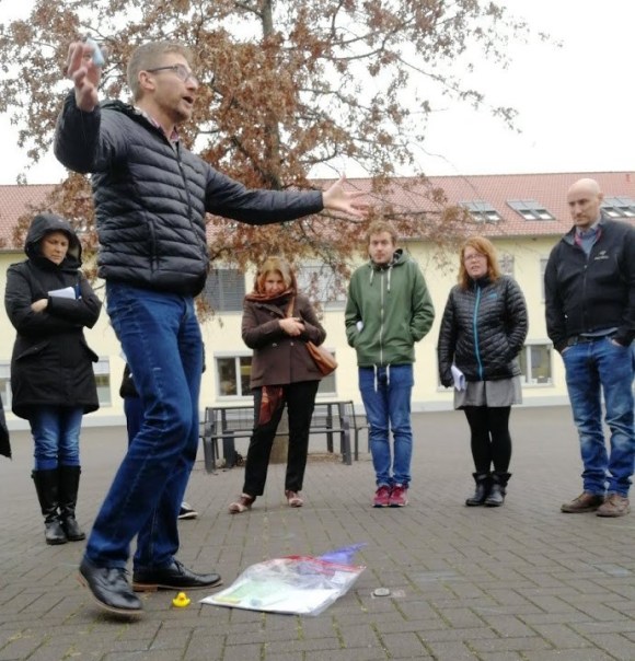
Circle formation
This is often the best way to communicate in the outdoors, due to wind/traffic noise/blocked views.
Use of props
Chalk can be used to draw pie charts, bar charts, or to demonstrate tallies based on compass wedges.
Toilet rolls (or ropes) could be used as contour lines, or timelines, or to help with a ‘journey to the centre of the earth’: https://www.earthlearningidea.com/PDF/196_Journey_centre_E.pdf.
Rubber ducks could encourage students to take photos of as many places as possible – challenge students to ‘see how many places you can put the duck’!
Use the environment to help you
Use the natural and built environment to help you.
E.g. use slopes as amphitheatres; trees as rain cover; environment and passers-by as story prompts (what is that person doing?)
Find elements of built environment to use too – e.g. steps could be used for ‘steps to empathy’ – see South Sudan activity from Oxfam UK: https://www.oxfam.org.uk/education/resources/south-sudan , slopes for contours (NB look for a viewpoint), and so on.
A hook
Important to find a hook for an outdoor learning experience – e.g. news story, Sixth Former having difficulty parking, etc
e.g. Geography of Crime – Where on the school campus do students feel secure? Where do they leave their belongings?
e.g. Urban Task Force – e.g. Lister Park – this could be done as a School Task Force – pupils could draw on safer cycling/walking/parking layouts in chalk? Design a place for children/humans rather than cars – link to Jan Gehl’s ‘The Human Scale’: https://www.youtube.com/watch?v=Ri4CeM0xUr0 and http://gehlarchitects.com – class members picture themselves as urban researchers and developers along Gehl’s lines. Then share with SLT/estates team/councillor/local paper/Neighbourhood Watch group/Facebook group/etc
Using the circle for sampling
One way is to use the circle idea from before, and ask students to look at a point in the distance and walk towards it, gathering data as they approach it.
Using your senses
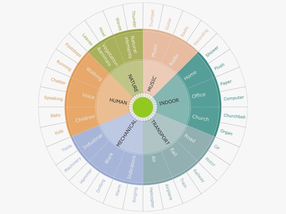
Soundscape Wheel – source: www.goodcitylife.org
Hearing: Turn around, and close your eyes for 30secs, focus on what you can hear, then note it.
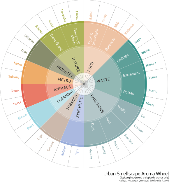
Smellscape Wheel – source: www.researchswinger.org
Smell: Ditto for smell.
Sight: it’s very easy to get distracted, so consider using cards, adapted from the Field Studies Council – www.field-studies-council.org – to get your students to stick to what they see – e.g. follow a bird, follow a line, sit on a bench and see what happens, look at your feet.
Emotional mapping – see extract from Teaching Geography (Autumn 2018) – www.geography.org.uk
Other ways of sampling
- Systematic: photo every 2mins/1 lamppost
- Line transect: buy day rider and get off at every bus/train/tram/underground stop
- Random:
- Dice
- Online random number generator: turn your study area into a 10×10 grid (or use random numbers to allocate squares then do 10×10 within this)
- Follow a contour as close as possible / visit all spot heights
- Inspired by Mission:Explore:
- Dérive: pick a person and follow them
- Toss coin several times before leaving, to help you plan your ‘random’ route: heads=turn right, tails=turn left
- Let your dog take you for a walk
Data collection methods
Beyond the questionnaire (credit is again due to Mission:Explore – www.missionexplore.net – for some of these ideas)
Cappuccino index – in order to assess the affluence of different customers, students (post-16) plot the cost of a medium cappuccino at all the cafes they pass en route. Then, back in the classroom, they plot these figures as proportional symbols and/or isolines. [Source: Simon Hinchliffe]
Word clouding – students ask passers-by to come up with five words to describe the area – or they might present the passers-by with a table of 20-30 terms which they would use. Back in the classroom, the students input the data into www.wordle.net to produce a ‘word cloud’
Set up a stall to collect positive messages about area
Set up a legal graffiti wall, photograph it every hour/day
‘Plug in and turn off’ – i.e. pretend to listen to music but actually listen to conversations and note down recurring themes
Empathy – students wear a blindfold or vision impaired glasses to start to empathise with the point of view of someone with a disability. Or they could get on their knees to get a child’s-level view, and take photos from both perspectives.
Spend a day as a refugee – limited budget for lunch/ hand out guide in another language to empathise with a refugee
Historical maps to work out what has changed and why: https://digimapforschools.edina.ac.uk/
Poetry – read out poetry that is set in your place of study
Video viewpoints – go to the place a video was taken from and show historic footage filmed from that viewpoint (e.g. first film – Leeds Bridge – https://www.youtube.com/watch?v=yJLr0cTzRYk )
Blue plaque quest – note name, sex, age, years – and reason for fame
Statue study – Investigate the statues in a place. How are men and women differently represented? Share a photo of the most typical statue you can find.
Rename and rebrand 1 – name the section of the walk that you have just undertaken – what would sum up its essential nature? What might attract different groups of people to undertake the walk? How might you publicise it? (e.g. Dijon and Leeds have Owl Trails – http://www.leedsowltrail.com/ – and the Chevin Geology Trail – http://chevinforest.co.uk/uploads/Geology/chevin_trail_2.pdf )
Rename and rebrand 2 – Ask your students to keep their eyes open during one particular neighbourhood. Don’t tell the students what the name of the neighbourhood/redevelopment district is that they have just explored. Instead, ask them to name it. Give them examples of (re)branding that have helped parts of cities get a new image – e.g. a run-down part of Salford became Media City; the part of Leicester that has the new Curve Theatre in it is called the Cultural Quarter.
The other side of the tracks? – Walk a route and, on a small map of the area, draw the boundary between rich/poor, old/young, safe/unsafe, etc. Or with red pen, draw boundaries that pedestrians might be wary of crossing. Or with a highlighter, highlight the most cycle-friendly/pedestrian-friendly roads in an area, and/or the most dangerous. For more ideas, see http://groups.ischool.berkeley.edu/mentalmaps/index.html
Urban Repair Squad – Where would you paint a new pedestrian crossing? Or bike path? Mark it on your map and/or use chalk to mark it on the ground. Some groups take matters into their own hands – Google ‘guerrilla gardening’ and http://grist.org/urbanism/2011-06-23-five-provocative-ways-to-think-about-cities-and-neighborhoods/
Graffiti spotting – jot down where graffiti is found and what it says. Consider why it is located there.
Care for the locality – How long do people wait before picking up litter on a path/bench/pick up an exercise book/a toy duck?! Repeat the experiment in different areas of the school/park.
Things to map
- CCTV cameras
- Gardens – look, area, biodiversity, smell, number of cars…
Dereliction/ to let/ for sale/ abandoned areas - Human communication (painted rocks, graffiti, council signs); colour code into do/don’t/neutral
Signs
What signs/words would you remove to make the area more pleasant?
What signs would you add?
Back to the classroom
So you have come up with a question, gathered data, presented it, analysed it, concluded and evaluated it (not time to go through the whole sequence of enquiry but Geographers are used to it)… but what next?
Many students engage better if they are given a choice of how to present their project. We are moving towards this at BGS, with aim of at least one ‘multi-outcome’ task per year group. Sometimes this could be a simple choice between a talk, a poster, or a presentation. Or, as in our Year 9 South Sudan project, it could be, for example, to teach a lesson to a class, create a social media campaign complete with a website, or write a letter to your MP. This allows for individual and group work.
Taking it further – cross-curricular outdoor learning
In June 2018, all 120 Year 9 pupils at Bradford Grammar School www.bradfordgrammar.com enjoyed a day of outdoor learning. The purpose was to demonstrate to pupils (and staff) how learning can take place outside the classroom, and to increase resilience to its challenges (e.g. to prepare them for navigational demands of DofE). Please contact me if you would like to run such a day at your school.

4 replies on “Let’s take this outside – ideas for outdoor learning in the humanities and beyond”
[…] This post also appears at: https://alcockblog.wordpress.com/2018/11/09/lets-take-this-outside-ideas-for-outdoor-learning-in-the… […]
LikeLike
[…] ideas in the Outdoor Classroom Day website – and in some of my earlier blog posts, such as this one. Finally, the ‘hive mind’ of the Bradford Grammar School staff helped in the […]
LikeLike
[…] Outdoor Learning has re-shared this 2018 blog post which includes useful activities for mapping and sampling outdoor places and spaces. These would […]
LikeLike
Awesome bloog you have here
LikeLike