Categories
Geography Optimism and progress Teaching and Learning Uncategorized

Optimism, progress and geography – celebration and calibration

TG article Autumn 2019

In the most recent edition of the Geographical Association’s journal ‘Teaching Geography’ (Autumn 2019) I write about how geography teachers can help our students to become aware not only that the world faces severe challenges, but also that progress has been made, and to learn about past successes so that they can be built upon.

Inspired by ‘Factfulness’ (Hans and Ola Rosling and Anna Rosling Ronnlund, 2018), ‘Enlightenment Now’ (Steven Pinker, 2018) and other sources, I explore common misconceptions about the world held by students (and many teachers too!).  Then, adapting a framework suggested by Bobby Duffy in ‘The Perils of Perception’ (2018), I suggest ways that teachers can recognise and begin to address such misconceptions.

I conclude by asserting that “The raison d’etre of geography is to ‘write about the world’, so for the sake of our students, our discipline and wider society, let’s give it our best, most accurate, shot.”

Copyright restrictions mean that I can’t go into more detail, but I urge Geography teachers to join the GA and subscribe to the journal to keep their subject knowledge and pedagogy up to date: www.geography.org.uk

Categories
Geography Optimism and progress Teaching and Learning Uncategorized

Nine things that climate change and human progress have in common

The bumblebee

Source: Trounce [CC BY-SA 2.5 (https://creativecommons.org/licenses/by-sa/2.5)%5D, from Wikimedia Commons

Pause for a second and consider these short ‘earth stories’:

  • A Nigerian child is vaccinated against polio
  • The bumblebee’s habitat declines in Europe and North America
  • A sesame farmer in Tanzania buys his first bicycle
  • A British farmer decides to plant some grapevines

These kind of ‘earth stories’ rarely make the headlines.  Yet they are all part of the unfolding history of our planet.  Together with millions of other ‘earth stories’, they give us an insight into how we are interacting with our habitat in two key areas: climate change and human progress.

Understanding climate change and recognising the progress made by humankind are central to the future of our planet and of our species.  But neither gets the attention that they deserve.

But why have they both failed to get traction in the public’s consciousness?  The reasons are manifold:

  • Their manifestations are incremental. The 24-hour news cycle, human discourse, and the fast-moving world of business tend to favour more sudden, attention-grabbing events and narratives rather than drawing our attention to trends which occur over decades (such as climate change) or even centuries (such as human progress).


  • Both are complex in terms of their causes and implications. This makes them hard to comprehend, and so it is very tempting for individuals, governments, businesses, educational establishments, and other organisations, to shy away from an in-depth understanding of them.  Complex challenges – also known as ‘wicked problems’ (Rittel and Webber, 1973) – have been recognised as a key focus for modern and post-modern societies – but the hard work in translating this into practical measures has yet to begin in earnest.


  • ‘Human progress’ and ‘Climate change’ are both contested terms. I have written elsewhere about the difficulty in pinning down my worldview in relation to progress, but of course even the term ‘progress’ is a difficult one to pin down:  What spheres of ‘progress’ should we be considering?  Whose ‘progress’ should we have in mind?  How can it be measured?  I have referred to the work of Steven Pinker in previous posts and I believe that he does a good job of summarising ‘progress’:

“What is progress?  … Most people agree that life is better than death.  Health is better than sickness.  Sustenance is better than hunger.  Abundance is better than poverty.  Peace is better than war.  Safety is better than danger.  Freedom is better than tyranny.  Equal rights are better than bigotry and discrimination.  Literacy is better than illiteracy.  Knowledge is better than ignorance.  Intelligence is better than dull-wittedness.  Happiness is better than misery.  Opportunities to enjoy family, friends, culture, and nature are better than drudgery and monotony.”  (Pinker, 2018: p.51)

However, others will disagree on what exactly constitutes progress, or will want to place different weightings on its constituent measures.


  • Obtaining an accurate and unbiased verdict on their current status is difficult. This is the case firstly because both spheres are politically sensitive and therefore most messages come to us via media which are subject to their own biases. Also, even though there exists a wide body of evidence to help us to reach conclusions, this body is so wide, and so dynamic, that it is difficult to synthesise.


  • Both have vested interests who find it hard to accept nuances and exceptions to their stated positions on one side or another. This means that there is considerable muddying of the water around the concepts. For the more outspoken and controversial proponents of human progress, such as Matt Ridley, the picture seems exasperatingly clear – the world is getting better – look at the proof!  But inadequate consideration is still given to the environmental (and social) problems caused by some of the progress made by humankind.  For many climate change activists, it is anathema to concede any benefits of climate change, whereas many sceptics, who have only just conceded that anthropogenic climate change is real, struggle to admit that it will harm the world’s poor more than the rich.


  • Both seem to escape easy academic categorisation. Which discipline – if any? – should take human progress under its wing?  And what about climate change?  Universities have led the way with interdisciplinary departments and projects relating to climate change, but at secondary education level, it is only recently that disciplines outside of Geography have begun to explore it.  Meanwhile, human progress is such a contested term and covers such a wide range of human experiences that it has an even more diffuse academic grounding – and as it is often stigmatised (with, admittedly, some good reason) as being a hobby horse of the right, then it is in danger of being shunned by the academy in favour of more fashionable and ostensibly more socially acceptable concerns.


  • Both seem to have been side-lined by successive governments. In the UK, should the crucial task of tackling climate change be given its own department of government?  Or should it belong to the Department for Environment, Food and Rural Affairs?  Either would seem to be sensible – but it is in fact the responsibility of The Department of Energy and Climate Change – two areas which have historically been antagonistic in their priorities.  What about human progress?  Should responsibility for this lie solely with the Department for International Development?  If so, who is responsible for tracking human progress in areas that DfID is not active in, and what about human progress in the UK?


  • Neither issue – particularly human progress – has gained much political traction. Many voters are much more likely to prioritise issues that are closer to home than to pay attention to global issues, especially if they are either misinformed or uninformed about their key roles in the future of the planet.


  • Both terms lead to reactions that are psychologically complex. Just one example is the cognitive dissonance experienced from holding the same two views simultaneously, such as ‘a holiday would do me good’ and ‘flights are one of the most damaging actions that can be taken in terms of carbon emissions’. Sometimes it is easier to avoid thinking about the deeper consequences of one’s actions than to confront them, question them, and act accordingly.  In the context of climate change, George Marshall (2014) has written about the psychological mechanisms that allow us to know something is true but to act as if it is not.


Concluding thoughts

How and when will these barriers be overcome?  When the twin UK obsessions of Brexit and Trump pass, as surely they will, who will set the tone for future social and environmental discourse?

When will a tipping point be reached in either sphere?  When will the default position of anyone (or indeed any algorithm) considering any significant action be to consider the impact of that action on climate change?  When will there be widespread acceptance of the generally positive trends seen in terms of human progress?  As ever, your thoughts are welcome.

David

Bibliography

Marshall, G (2014) Don’t Even Think About It: Why Our Brains Are Wired to Ignore Climate Change (Bloomsbury)

Pinker, S (2018) Enlightenment Now: The Case for Reason, Humanism and Progress (Allen Lane)

Ridley, M (n.d.) www.rationaloptimist.com

Rittel, H and Webber, M (1973) ‘Dilemmas in a General Theory of Planning’ in Policy Sciences 4 (1973), pp155-169: https://web.archive.org/web/20070930021510/http://www.uctc.net/mwebber/Rittel+Webber+Dilemmas+General_Theory_of_Planning.pdf

Categories
Geography Uncategorized

The little island with a large volcano – Part 2: Impacts and can the future be self-sufficient?

“[T]he epoch-making eruption of the Soufrière Hills volcano in 1995… has affected almost every facet of life in this 39.5 square mile island.  Agriculture, industry, land-form, land space and its use, demography, politics, culture and the totality of society have all undergone changes of revolutionary proportions” (Fergus, 2007: 9)


In the previous article, we considered the physical processes involved in recent volcanic activity on Montserrat, with particular reference to the fifth phase of activity (October 2009 – October 2010 and ongoing), together with an assessment of monitoring techniques.  In this article, we will explore the social, economic and environmental impacts of this activity, and we will briefly assess the likelihood for Montserrat to become self-sufficient in the future.

Montserrat map locations (Wikimedia)

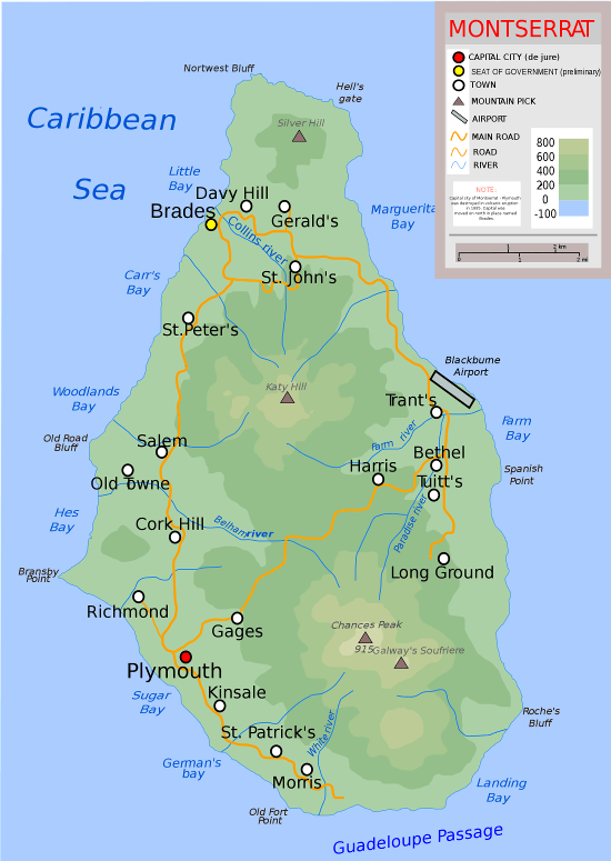
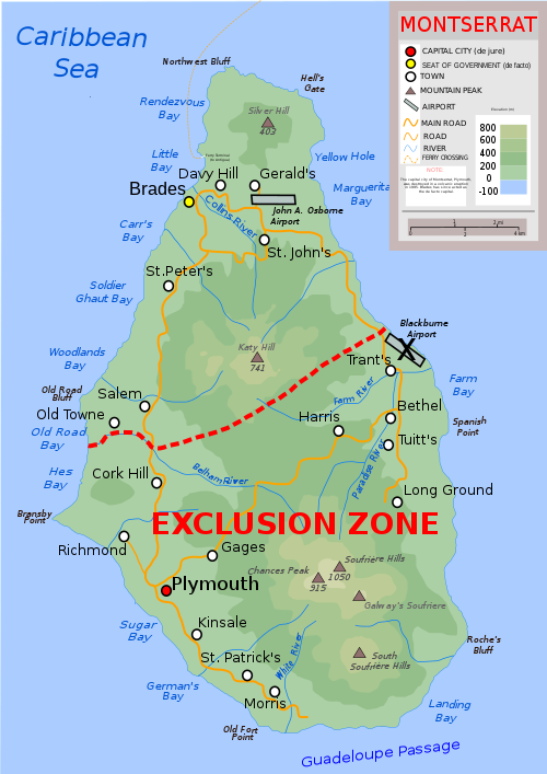
Figure 1: Map of Montserrat

Source: http://www.paradise-islands.org

Social impacts and plans for the future

Between 1995 and 1999, Montserrat experienced a huge exodus following the destruction of the capital, Plymouth (see Figure 2), and the forced evacuation of many villages and farmland in the southern part of the island (see Figure 3).  In this short time span, the island’s population decreased to about a third of its pre-eruption levels, from 10,000 to 3,000, rising to just over 5,000 by 2006.  This ‘diaspora’ has settled in many countries, mainly Antigua, the UK and the USA.  These migrants joined a large group of people who had already left the island throughout the twentieth century, for example in the aftermath of Hurricane Hugo in 1989.  The exodus in the late 1990s resulted in a loss of economic potential, because a large number of the emigrants were from economically active age groups.  Another impact of the eruption has been the arrival of over 1,500 people from other Caribbean islands who have been attracted by employment opportunities, chiefly in construction.

2 fig 2 Plymouth

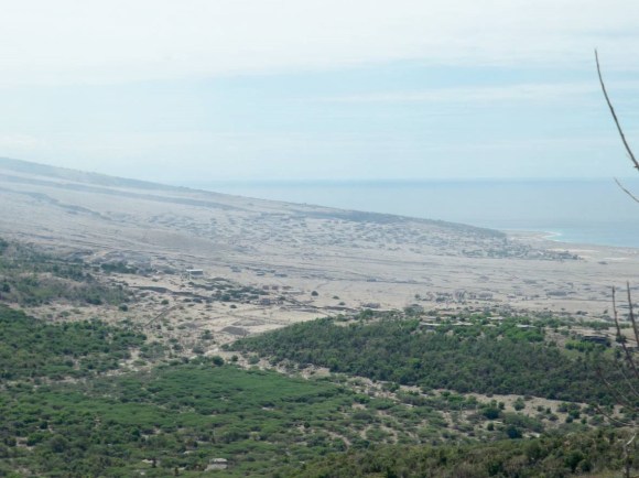
Figure 2: View of Plymouth from the north

Source: Author

2 fig 3 Hazard Zones

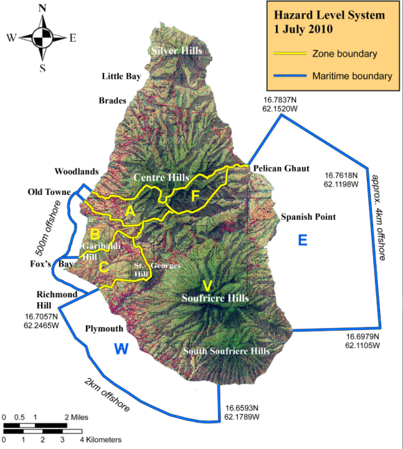
Figure 3: Montserrat hazard zone map (1 July 2010)

Source: Montserrat Volcano Observatory: http://www.mvo.ms

For those Montserratians who have remained, there have been health effects, although these have been well controlled.  The main effects have been the exacerbation of respiratory diseases, silicosis (a kind of lung disease caused by christobalite, an element found in the ash), and post-traumatic stress disorder.  Psychologically, many Montserratians felt under threat in the months following the initial eruptions, and these tensions were heightened by the crowded life in evacuation centres.


Key terms

Diaspora: The population of a country who has migrated abroad and who keep strong ties with their country of origin

GDP: Gross Domestic Product, i.e. the total value of goods and services produced by a country, usually stated over the period of a year

Quango: quasi nongovernmental organisation; an organisation that is financed by the government yet acts independently of it

Anthropogenic: resulting from the influence of human beings

Feral: a plant or animal that has escaped from domestication


Looking to the future, one of the five strands of the island’s Sustainable Development Plan 2008-2020 (see the relevant section at the end of the article) is to achieve a sustainable population: the government hopes to “develop and implement population, labour and immigration policies which will enhance the growth of the population; create initiatives to retain the current population; and create incentives which will facilitate the increase of the population” (Ministry of Economic Development and Trade, Government of Montserrat, N.D.: 7).


Educationally, enrolment in all schools, from nursery to secondary, dropped from 2672 to 620 between 1995 and 1998.  The two secondary schools were consolidated into one, but the school has had problems in retaining staff; most teachers come from other Caribbean islands, and 8 out of the 35 staff departed the school at the end of the 2009/10 academic year.  A community college opened next door to the secondary school in 2005.  New methods of teaching and learning have been introduced to the school and the college, to put the students on a better footing for the future.


Economic impacts and plans for the future

Economically, the volcano dealt the island a blow from which it is still struggling to recover.  The land adjacent to the volcano was some of the most fertile on the island; such land is now agriculturally useless and inaccessible (see Figure 4), and 300 full-time farmers have been dispossessed by the eruptions.  Montserrat, which used to be self-sufficient in many crops, is now dependent on imports for the vast majority of its foodstuffs.  This is clear to see from a brief visit to any of the island’s food stores, and symptomatic of this import dependency is the fact that it can be difficult to buy limes on an island which was once famous for its lime crop (relaxing is still known as ‘liming’ on the island).  There are seeds of hope, however: following a government campaign, many residents have turned towards growing some of their own crops, such as sweet potatoes and papaya, and the frequent ash falls have increased the fertility of the soil.

2 fig 4 hazard sign

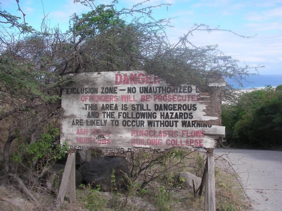
Figure 4: Exclusion Zone sign (2010)

Source: Author

Manufacturing industry was strong on the island until the first eruption: it hosted assembly-type businesses and food processing plants, dominated by Montserrat Rice Mills.  Until the evacuation of Plymouth, the island also hosted an off-shore medical school, the American University of the Caribbean, which employed dozens of staff, and whose 400 students had been significant spenders in the local economy.  Future plans to re-invigorate the island’s economy include the expansion of the ash processing industry (see Figure 5) and the construction of a new capital city in Little Bay (see final section and Figure 1).  The music producer George Martin has already funded the recently completed Cultural Centre at a cost of nearly US$3 million to kick-start this development.

2 fig 5 Montserrat Blocks

Figure 5: A potential economic benefit of the activity?

Source: Author

Tourism was another big loser thanks to the eruption: the airport and seaport were in the exclusion zone, huge areas were declared out of bounds, and tourists were deterred by negative travel advice from their governments.  In 2004 a £5 million grant from the UK’s Department for International Development (DfID) was secured: some of it was used for ‘capacity building’ (supporting hotel and villa construction), and part of it was spent on hiring a team of consultants from Scotland: ‘Team Tourism’.  Their strategic plan for the island seeks to widen the number of target markets.  The traditional ‘Caribbean’ target markets have been characterised by the phrase ‘newly weds and nearly deads’, the latter referring not only to the substantial cruise ship market but also to the thousands of ‘snowbirds’ – wealthy retirees from northern America who own villas and use them for several months during the winter.  The consultancy renamed these tourists as ‘destination enjoyment’ travelers, and came up with eight more target markets (see inset), along with a new logo and a slogan which elliptically refers to the volcano as a possible attraction: ‘A Caribbean Treasure – Spectacular by Nature’.


2 fig 7 tourist logo

Figure 6: Montserrat Tourist Board logo

Source: http://www.visitmontserrat.com

Tourism target markets:

– ‘Destination enjoyment’ holidaymakers (especially villa owners and renters)

– Markets inspired by the volcano (volcano tours and the education market)

– The dive market

– The bird watching market

– The cruise market

– The yachting market

– The market for day visits, short breaks and events

– Sports tourism (football and cricket)

– The Montserrat diaspora

Source: Team Tourism (2007)

2 fig 8 air travel

Figure 7: The new airport has a shorter runway than the previous one and can only take small aeroplanes

Source: Author

At the peak of the volcanic activity in 1997, the annual number of tourists was approximately 4,000.  By 2004, a ferry linking Montserrat with Antigua, with two sailings a day had been established, and this ferry facilitated an influx of day visitors.  The estimated number of tourists at this time was 15,000.  When the subsidy stopped in 2005, the ferry service ceased, and by 2006, the numbers had shrunk to 9,500: the Director of the Tourist Board, Mrs Ernestine Cassell, states that “the capacity of the ferry and the small size of our airport severely restrict the number of visitors which come to the island… and will continue to do so for the foreseeable future”.  Another drawback for potential ‘volcano tourists’ is that tours around the site of Plymouth (‘the new Pompeii’) have not taken place for several years thanks to continued volcanic activity.


Energy is one of the most significant economic challenges which face the island.  Today, the island relies upon one relatively inefficient high-speed diesel engine.  The island’s 2008-2020 Sustainable Development Programme has, however, identified renewable energy as a priority for the island.  Some renewable options are, as Director of Montserrat’s Department of Energy, Peter White puts it, “definitely on the back-burner”; these include tidal, whose capital costs are high and whose prospects are low thanks to the low tidal range of the Caribbean Sea, and wave, which also suffers from a high capital cost.  Wind energy, which was trialled in the early 1990s, and which contributed 400kWh at its peak, looks likely to mothballed for a longer period, partly because of a lack of suitable sites (the Centre Hills is due for designation as a National Park), and partly because the direction of the usually reliable ‘trade winds’ has seemingly shifted, meaning that orientating the turbines may be problematic.


For a location in the Caribbean, solar energy might be seen as a possible solution.  However, wide-scale deployment of photovoltaic solar panels has a high capital cost, and there is insufficient space for a large-scale installation.  Recent changes in the direction of prevailing winds on the island also mean that the northern part of the island has seen increasing ash falls, which can obscure the sunlight reaching the panels.


Geothermal energy is the main focus of the department’s renewable energy strategy.  A suitable aquifer, recharged by the sea and fresh water, has been found in Foxes Bay, in Zone C of the Exclusion Zone, between Richmond and Gages (see map).  The planned capacity of this small plant is in the range of 2-5MW, therefore supplying all of the electricity for Montserrat at its current population size, and possibly allowing for Montserrat to be a net exporter of electricity.  Funding is being sought from a variety of sources, but Peter White is struggling to obtain funding for the project.  Current plans for the installation of a medium-speed diesel engine mean that Montserrat will still be open to the mercies of the open market in oil prices.


Environmental impacts and plans for the future

On a regional scale, as mentioned in part 1 of this article, ash from the 11 February dome collapse reached several neighbouring islands, resulting in extensive disruption to air travel in the Eastern Caribbean region, and it also caused millions of pounds worth of damage to banana and other cash crops on Guadeloupe alone.


On Montserrat, the most obvious environmental effect has been the destruction of approximately a third of the island’s tropical rainforest and much of its wildlife.  In addition, ash falls have thwarted vegetation growth in the short-term.  However, the ash has enriched the soil with iron, magnesium and potassium from the weathering of various minerals, such as olivine, pyroxene, amphibole, and feldspar which are found in volcanic ash.


However, perhaps the most notable environmental impact which humans have some degree of involvement in is the effect of feral animals on the island’s ecosystem.  The island’s forests support critically endangered endemic species including the Montserrat Oriole (a bird), Montserrat Galliwasp (a lizard) and Mountain Chicken (actually a frog!).  Feral pigs (see Figure 8) and goats (together with smaller numbers of cattle and donkeys) originating from abandoned livestock in the Exclusion Zone are thought to be dramatically increasing in number in the Centre Hills.  Such animals are damaging native plants and animals, including endemic species, and spreading of exotic species.  They may also be leading to increased soil erosion, agricultural damage, pollution of water and attacks on walkers.

2 fig 9 feral pig (Mont Govt)

Figure 8: Feral pig on Montserrat

Source: Montserrat government: http://www.gov.ms

Richard Bunting, a wildlife ecologist working in collaboration with the Department of the Environment, on a Darwin Initiative project, has been using a number of fieldwork techniques to investigate the impact of such animals on the biodiversity of the Centre Hills region.  These techniques include monitoring a network of infra-red cameras (using food traps to attract animals), driving through the island to count loose livestock, and surveying farmers.  Possible solutions to the problem include controlled hunting, encouraging farmers to tie up feral animals, and laying traps.


Volcanic activity and climate change – did you know?

On a global scale, whenever the volcano erupts, vast volumes of carbon dioxide and sulphur dioxide are emitted into the atmosphere.   Whilst it is virtually impossible to accurately measure the volumes of carbon dioxide which comes from the Soufrière Hills volcano, it is useful to put such emissions in context: even if you take the highest estimate of global volcanic carbon dioxide emissions (270 million metric tons per year), human-emitted carbon dioxide levels are more than 130 times higher than volcanic emissions (Gerlach, 2010).


What is the likelihood that Montserrat might become self-sufficient?

In 2008/09, Montserrat relied upon an annual aid budget of £16.4 million from the UK’s Department for International Development (DfID, 2010), a figure equivalent to over £3000 per resident.  It also receives a smaller amount of aid from other international organizations, for example the EU.  The UK coalition government has committed to reprieve overseas aid from its programme of cuts, and anecdotal evidence suggests that Montserrat is unlikely to become self-sufficient in the near future.

The island’s ‘Sustainable Development Plan 2008-2020’, aims for a degree of self-sufficiency: this is summarized in Inset 4, below.  By 2010, some aspects of the plan had already been delivered: these include the completion of Phase 1 of the construction of the new capital at Little Bay in the north of the island (see map) and the current push to invigorate tourism on the island.  There has also been a campaign to try to encourage the 30,000-strong Montserratian diaspora to invest in the island and to consider returning to it.


Strategic Goals of the Montserrat Sustainable Development Plan, 2008-2020

– Economic Management: An environment that fosters prudent economic management, sustained growth, a diversified economy and the generation of employment opportunities

– Human Development: Enhanced human development and improved quality of life for all people on Montserrat

– Environmental Management and Disaster Mitigation: Montserrat’s natural resources conserved within a system of environmentally sustainable development and appropriate strategies for disaster mitigation

– Governance: An efficient, responsive and accountable system of governance and public service

– Population: A sustainable population

Source: Ministry of Economic Development and Trade, Government of Montserrat (N.D.)


So, will Montserrat ‘rise from the ashes’?  Whilst researching for these articles, it has become evident that although the initial shock of volcanic activity on Montserrat has passed, the volcano shows no signs of ceasing its activity, and the impact of this activity is profound and will be long-lasting.  The journey to self-sufficiency will be slow and difficult, and only time will tell whether the residents of this ‘little island’ will have the strength and perseverance to tame the powerfully destructive effects of their ‘big volcano’.


Key points

  • The social, economic and environmental impacts of the eruption of the Soufriere Hills volcano have been significant and long-lasting
  • A new capital city, ash processing, tourism and geothermal energy may provide the basis for future development on Montserrat
  • Montserrat has begun a long journey towards self-sufficiency


Points for discussion

  1. How does Montserrat’s position as a British Overseas Dependency disrupt received notions of ‘developed’ and ‘less developed’ countries?
  2. How would you set Montserrat on a ‘journey towards self-sufficiency’?


Further reading

Montserrat Sustainable Development Plan 2008-2020: http://www.gov.ms/?p=1498

Department for Overseas Development – Montserrat Overview: http://www.dfid.gov.uk/Where-we-work/Overseas-Territories/Montserrat/


Acknowledgements

This article was written following a field-trip to Montserrat with Dr Caroline Neuberg, Physics teacher at Fulneck School, Leeds, and three sixth form students at the school.  The trip was made possible thanks to grants from the Seismic Schools Initiative based at the School of Earth & Environment, University of Leeds, UK (a seismometer was installed at the Secondary School) and the Royal Society.  I am indebted to Professor Jurgen Neuberg from the University of Leeds for his help on the field trip and his comments on the text.  Finally, I would like to thank all the interviewees mentioned above.


The author

David Alcock is Head of Geography at Fulneck School, Leeds and is an AQA examiner.


Below are the sources referred to in the text.  I am aware that you will probably remove all references from the body of the text, but you may find these useful for verification purposes:

MVO – Cole, P. et al (2010) ‘Report to the Scientific Advisory Committee on Montserrat Volcanic Activity – Report on Activity between 15 August 2009 and 28 February 2010’ (‘SAC 14’) at http://www.montserratvolcanoobservatory.info


BBC (1999) http://news.bbc.co.uk/1/hi/uk/312910.stm


DfID (2010) http://www.dfid.gov.uk/Where-we-work/Overseas-Territories/Montserrat/


Fergus, Howard A. (2007) ‘Montserrat: Defining Moments’


Gerlach, T. (2010) ‘Voices: Volcanic versus anthropogenic carbon dioxide: The missing science’ at http://www.earthmagazine.com/earth/article/371-7da-7-1e (posted 30 July 2010)


Loughlin, S., Baptie, B. and McCourt, W. (2009) Monitoring Montserrat’s volcano – past, present and future

http://planetearth.nerc.ac.uk/features/story.aspx?id=396 dated 10 July 2009


Ministry of Economic Development and Trade, Government of Montserrat (N.D.) ‘Montserrat Sustainable Development Plan 2008-2020: Montserrat Medium-Term Strategy and Action Plan 2008-2012’


Montserrat Government (2010) ‘Darwin Feral Livestock Project’, www.gov.ms/?p=1812, dated 7 January 2010


Team Tourism (2007) ‘Tourism Development in Montserrat 2008-10 Strategy Review and Implementation Framework November 2007’


Wikimedia (accessed 2010) Map of Montserrat: http://upload.wikimedia.org/wikipedia/commons/thumb/8/82/Topographic-map-of-Montserrat-en.svg/500px-Topographic-map-of-Montserrat-en.svg.png

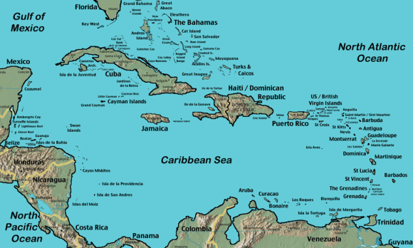
and Map of Caribbean

http://en.wikipedia.org/wiki/File:CaribbeanIslands.png


Categories
Geography Uncategorized

The little island with a large volcano – Part 1: how is volcanic activity on Montserrat monitored?

Aerial view Montserrat

Figure 1: View of Montserrat from International Space Station, 2009

Source: http://earthobservatory.nasa.gov/IOTD/view.php?id=40803&src=eoa-iotd

All A-level examination specifications have tectonic hazards as an option.  It can be difficult to keep up-to-date with recent case studies, especially those concerning continuing volcanic events and long-term responses.  Montserrat is a popular case study, but its appearance in some of the most popular Key Stage 3 and GCSE textbooks might put students off revisiting the case study at A-level.  However, the situation in Montserrat is complex and constantly changing, and this justifies revisiting the ‘little island with the large volcano’.  In this article, we will consider the physical processes involved in recent volcanic activity, and we will assess the monitoring and prediction techniques employed on the island.  In the second article, we will consider the long term impacts of the eruptions and the potential for the island to become self-sufficient.

Montserrat map (Wikimedia)

Figure 2: Location of Montserrat – in the easterly part of the Caribbean

Source: https://www.cia.gov/cia/publications/factbook/reference_maps/pdf/central_america.pdf

Montserrat map locations (Wikimedia)

Figure 3: Map of Montserrat

Source: http://www.paradise-islands.org

Phases of volcanic activity

Scientists at the Montserrat Volcano Observatory (MVO) have divided the volcanic activity into five phases interrupted by pauses:

Phase 1: Summer 1995 to the start of 1998

Phase 2: December 1999 to Summer 2003

Phase 3: Summer 2003 to Spring 2007

Phase 4: Summer 2008 to 3 January 2009

Phase 5: 4 October 2009; ongoing (at time of writing – i.e. October 2010)


The main events which Geography students will be familiar with occurred in Phase 1.  Following over three hundred years of inactivity, there were a few precursors of activity early in 1995, in that steam was seen rising from the vent, and mud pools increased in temperature.  The first eruption of the Soufrière Hills Volcano started on 18 July 1995, and this initial eruption led to the evacuation of the capital, Plymouth, and the creation of an exclusion zone in the southern part of the island.  On 25 June 1997 at about 1pm, a much larger eruption occurred. The dome of the volcano collapsed, sending 5 million cubic metres of hot rocks and gases down the side of the volcano.  These ‘pyroclastic flows’ killed 19 people who returned to their farms in the exclusion zone, and they also created an area of new land as some debris was deposited off the coast.  Activity in Phase 1 had significant impacts on the society (notably the emigration of over half of the island’s population), economy and environment; these will be dealt with in detail in the next article.  Activity in Phases 2-5 has been significant enough to warrant the continuation of the exclusion zone, although no further fatalities have occurred.  We will now investigate the most recent phase, to give some idea of the events associated with a volcanic eruption.


Phase 5 of volcanic activity

Phase 5 has enjoyed more media exposure than all but the first phase, partly owing to the publication of an aerial photograph of the eruption taken by an aeroplane passenger in the national press and on several websites (see Figure 4).

Montserrat view from plane (source Metro)

Figure 4: 2010 eruption, taken by an aeroplane passenger

Source: http://www.solentnews.co.uk/

Phase 5 began on 4 October 2009, and was preceded by two days of decreasing gas output and an hour of small volcano-tectonic (VT) earthquakes.  Ash was vented for the first four days, the dome grew, and pyroclastic flows were recorded, some of which reached places which had never been reached before.  This episode ended with five Vulcanian explosions (powerful eruptions of blocks of viscous lava, also known as ‘volcanic bombs’) throughout a five-week period in January-February.  At 11.52am on 11 February, an estimated 40 million cubic metres (approximately 20%) of the north-eastern portion of the lava dome collapsed (see figure 5 below).  This led to several pyroclastic flows and surges.  One flow/surge combination headed down Farm Valley (see Figure 7), which had not previously been affected by such activity – this surge was so powerful that the MVO described it as being “a small lateral blast type pyroclastic surge”.  Lateral blasts will be familiar to students through the 1980 Mount St Helen’s eruption.  The deposits added 650m of new land was added to the island’s coastline at Spanish Point (see map – Figure 3).  This coastal accretion, together with other additions since 1995 have led to the joke that Montserrat is ‘the only part of the British Empire which is still expanding’.

MVO dome collapse (source MVO)

Figure 5: Partial lava dome collapse, 11 February 2010

Source: ‘Report to the Scientific Advisory Committee on Montserrat Volcanic Activity – Report on Activity’ at http://www.montserratvolcanoobservatory.info


These pyroclastic deposits (see Figure 6) consist of ash, together with blocks of ‘andesitic glass’ – a porous, light-grey rock which is ejected at great speed from the vent, trapping water vapour from the magma as it forms.  Some of this material is less dense than water, and it therefore often floats.  These deposits have crystals of pyroxene embedded in them – these originate from the mingling of basaltic (silica-poor) and rhyolitic (acidic and silica-rich) magma.  Once pyroclastic deposits settle, secondary explosions can take place – these occur hours, days, or even weeks after the flow.  In such explosions, groundwater or rainfall comes into contact with the well-insulated and very hot deposits merely tens of centimetres below the exposed upper layer.  The temperature can reach several hundreds of degrees Centigrade even at these shallow depths.  The 11 February event also generated ash clouds of up to 40,000ft (12,200m) in height; the west-southwesterly winds meant that the ash only fell on a small part of eastern Montserrat; it did, however, make landfall on islands such as Antigua, Guadeloupe, Dominica, Martinique and St Lucia.


Figures 6 and 7: Pyroclastic deposits

Source: Author

How is the Soufrière Hills volcano monitored?

One of the ultimate aims of monitoring volcanoes is to identify precursors of activity.  Of course, vulcanologists enjoy the advantage over earthquake seismologists of having a reasonable idea about where an eruption might take place, even if it is difficult to say precisely when activity is likely to take place.


The current monitoring system is maintained by staff at the Montserrat Volcano Observatory (MVO).  There are several monitoring stations situated throughout the island.  They are powered by solar panels, which continuously provide data to the MVO by radio link.  A continuing challenge to scientists has been the threat of pyroclastic flows, pyroclastic surges, and lahars, which have frequently put several stations out of action.  Sometimes, scientists have been extremely lucky; this was the case on 11 February, when a monitoring station was only 2 metres away from the ‘singe zone’ of the pyroclastic surge (see Figure 8).


The seismic network comprises twelve broadband seismometers which can detect ground motion in the frequency range from 0.03Hz to 50Hz: this range encompasses a range of movement, from human footfall, through rockfalls, to movements of magma deep underground.  The GPS network has nine GPS receivers detecting ground deformation with an accuracy of millimetres.  The gas spectrometers sample the plume for suplhur dioxide.


In addition, there are four monitoring stations set up by a British-American research project (SeaCALIPSO), each one containing a tilt- and a strain-meter housed in a 200m-deep borehole.

Fig 8 monitoring station

Figure 8: Monitoring station

Source: Author

Key terms

Pyroclastic flow: A surface-hugging eruption cloud of very hot gas and volcanic particles that moves rapidly across the ground surface

Pyroclastic surge: a surface-hugging hot cloud, less dense than a pyroclastic flow, moving with turbulent flow close to the ground surface (also known as a nuee ardente – French for ‘hot cloud’)

Lahar: A volcanic mudflow

Lava Dome: A build-up of viscous lava near a volcano’s vent

Ash venting: The release of small particles of volcanic rock and glass

Vulcanian explosion: A type of eruption consisting of the explosive ejection of incandescent fragments of new viscous lava, usually in the form of blocks

Volcano-tectonic (VT) earthquakes: seismic episodes originating from volcanic activity

Singe zone: The area adjacent to pyroclastic flow deposits, where vegetation has been partly or wholly burned


How is the monitoring equipment used?

The seismometers detect earthquakes, some of which, referred to as ‘low frequency events’ tend to appear in ‘swarms’ prior to an eruption.  Some of these are cyclic, as magma forces its way through subterranean conduits (passageways), and indicate that a dome collapse is likely to occur.  The GPS units are used to measure the ‘inflation’ of the island when magma builds up in a magma reservoir under the dome, and its ‘deflation’ following the extrusion of material (see figure 9).  Gas spectrometers are used to detect patterns of releases of sulphur dioxide, which is a measure of the overall permeability of the volcanic ‘plumbing system’.  The data from these networks can be combined into a single graph (see figure 10): red vertical bands show phases of extrusive activity (as mentioned above), whilst the green bands are when magma extrusion has paused.  The tilt- and strain-meters complement these data in that they enable vulcanologists to detect ground deformation.

Fig 9 displacement velocities

 Figure 9: Map of GPS measurements showing dome deflation

Source: ‘Report to the Scientific Advisory Committee on Montserrat Volcanic Activity – Report on Activity’ at http://www.montserratvolcanoobservatory.info

Fig 10 seismic events GPS SO2 (MVO)

Figure 10: Graph showing combination of monitoring readings

Source: ‘Report to the Scientific Advisory Committee on Montserrat Volcanic Activity – Report on Activity’ at http://www.montserratvolcanoobservatory.info


Note that whenever magma extrusion has stopped, the GPS signal indicates an inflation of the magma reservoir, while magma extrusion is accompanied by a deflation of the reservoir, and therefore a slight ‘sinking’ of the centre of the island.


Other monitoring techniques

Two additional stations contain arrays of infrasound sensors to detect air pressure variations caused by slow degassing or gas eruptions.  At the Montserrat Volcano Observatory itself, there is an observation platform and webcams, providing the benefits of a visual overview of activity, but with the drawback of being almost useless during times of heavy cloud cover and at night.  There is also a thermal camera, which overcomes these problems of poor visibility.


How effectively can volcanic activity on Montserrat be predicted?

To what extent do vulcanologists believe that they can predict when an eruption on Montserrat is likely to occur?  The Director of the MVO, Dr Paul Cole, uses a metaphor to explain why initial eruptions are usually relatively easy to predict:

“It’s much like an explorer creating a new path through the jungle.  When he first cuts his way through, it takes a lot of effort, and he makes a lot of noise as he slowly works his way through the undergrowth.  But with each repeated use of the path, the journey becomes easier, and there is less disturbance.  With volcanoes, if the vent has been used after a long period of inactivity, the magma has to break through and widen faults, creating seismic signals, but with each subsequent eruption, the magma encounters fewer obstacles, and therefore leaves behind a weaker seismic trace.”

Dr Cole also takes care to mention that the activity of some other volcanoes, particularly those with more basaltic (less silica-rich) magma, is more ‘predictable’ than that of the Soufrière Hills volcano.

In Montserrat, volcanic activity has occurred in phases, and there are a variety of characteristic signals which correlate with such phases.  However, it remains exceptionally difficult to predict when such phases are due to start or end, and it is equally hard to know when episodes of violent and extrusive vulcanicity will occur within these phases.  Monitoring the Soufriere Hills volcano has helped to minimise its impact on the island’s residents, but its eruptions have had serious effects on the society, economy and environment of Montserrat.  It is to these impacts that we will turn to in part 2 of this article.


Key points

  • The Soufriere Hills volcano has been active in distinct phases
  • Physical processes involved in eruptive phases are complex
  • Despite sophisticated monitoring techniques, predicting volcanic eruptions remains extremely difficult


Points for discussion

  • To what extent does media exposure influence our knowledge of hazards?
  • What monitoring techniques do vulcanologists share with seismologists?


Further reading

‘Report to the Scientific Advisory Committee on Montserrat Volcanic Activity – Report on Activity’ at http://www.montserratvolcanoobservatory.info

Loughlin, S., Baptie, B. and McCourt, W. (2009) Monitoring Montserrat’s volcano – past, present and future

http://planetearth.nerc.ac.uk/features/story.aspx?id=396 dated 10 July 2009


Acknowledgements

This article was written following a field-trip to Montserrat with Dr Caroline Neuberg, Physics teacher at Fulneck School, Leeds, and three sixth form students at the school.  The trip was made possible thanks to grants from the Seismic Schools Initiative based at the School of Earth & Environment, University of Leeds, UK (a seismometer was installed at the Secondary School) and the Royal Society.  I am indebted to Professor Jurgen Neuberg from the University of Leeds for his help on the field trip and his comments on the text.  Finally, I would like to thank all the interviewees mentioned above.